


.jpg)
Hoang Su Phi Trekking Map : Navigating Vietnam's Majestic Rice Terraces with Essential Maps
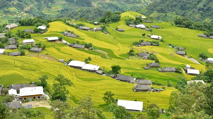
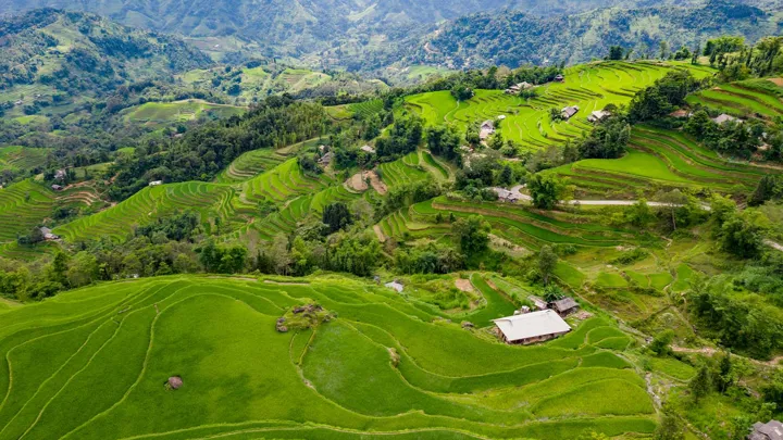
In the far western reaches of Ha Giang Province lies Hoang Su Phi, a mountainous district where time seems to slow down and landscapes still follow the rhythm of nature. Unlike many well-known trekking destinations in northern Vietnam, Hoang Su Phi remains largely untouched by mass tourism. Its terraced rice fields are not arranged for postcards but carved patiently over centuries by ethnic communities who continue to farm them today.
For travelers seeking raw beauty, meaningful encounters, and true exploration, Hoang Su Phi offers something increasingly rare in Southeast Asia: authenticity. And to truly experience it, understanding how to navigate this complex terrain is essential. This is where a Hoang Su Phi Trekking Map becomes not just helpful, but fundamental.
Why Hoang Su Phi Is the Next Chapter for Serious Trekkers
Sapa was once synonymous with mountain adventure in Vietnam. Today, however, its popularity has transformed it into a crowded destination with paved trails, tourist villages, and packaged experiences. While still beautiful, Sapa often feels curated rather than discovered.
Hoang Su Phi offers a striking contrast. There are no cable cars here, no souvenir streets, and very few signposted trekking routes. Villages remain scattered across steep hillsides, connected by footpaths shaped by daily life rather than tourism demand.
According to Vietnam tourism statistics, Sapa welcomed several million visitors annually in recent years, while Hoang Su Phi continues to receive a comparatively modest number of trekkers—mostly those intentionally seeking solitude and depth over convenience. This difference defines the experience.
In Hoang Su Phi, trekking is not an activity added onto travel. It is the journey. And without clear signage or commercial infrastructure, navigating responsibly requires preparation—starting with a reliable Hoang Su Phi Trekking Map.
A Living Landscape
More Than a Scenic View
The terraced rice fields of Hoang Su Phi are officially recognized as a National Heritage Site, but their value goes far beyond visual appeal. These terraces are living agricultural systems, maintained by hand and deeply connected to seasonal cycles.
Each village shapes the terraces differently, reflecting local knowledge, soil conditions, and water management traditions. When you trek here, you are walking through working landscapes, not preserved museums.

Ethnic Communities and Cultural Continuity
Over 90% of Hoang Su Phi’s population belongs to ethnic minority groups, including the Dao (Red Dao and Dao Ao Dai), H’Mong, Nung, and La Chi. Their houses, clothing, rituals, and farming methods vary from valley to valley.
Staying overnight in villages such as Ban Phung, Nam Hong, or Ho Thau often means sleeping in traditional wooden homes, sharing meals cooked over firewood, and learning how daily life unfolds far from urban centers. These experiences cannot be scheduled precisely—and that unpredictability is part of their value.
A Hoang Su Phi Trekking Map allows you to understand how villages relate spatially, helping you plan routes that respect local rhythms rather than disrupt them.
Why Navigation Is a Real Challenge in Hoang Su Phi
A Natural Maze of Terraces and Trails
Hoang Su Phi’s terrain is both stunning and deceptive. Terraced fields repeat visually, forest paths intersect without signs, and villages may sit just a few hundred meters apart vertically while requiring hours to reach on foot.
Mist and cloud cover are common, especially in early mornings and during the rainy season. Visibility can drop suddenly, turning familiar paths into confusing corridors.
Local trekking groups report that a significant number of first-time visitors struggle to locate homestays or planned overnight stops—even when they have received verbal directions. This is not due to poor preparation, but rather the inherent complexity of the landscape.
A Hoang Su Phi Trekking Map provides essential spatial awareness, helping trekkers anticipate elevation changes, river crossings, and village connections before stepping onto the trail.
Why GPS Alone Is Not Enough
Digital navigation tools have transformed travel, but Hoang Su Phi exposes their limitations.
Mobile signal is inconsistent, especially in deep valleys and forested slopes. GPS accuracy can fluctuate, and battery consumption increases rapidly during long trekking days. In cold or wet conditions, phone performance declines further.
There have been cases of trekkers forced to turn back after losing signal or running out of power—sometimes within short distances of their destination.
A physical Hoang Su Phi Trekking Map does not rely on electricity or connectivity. It offers a stable reference point, allowing you to adapt when technology fails.
The Three Core Benefits of Using a Hoang Su Phi Trekking Map
1. Safety Through Awareness
A trekking map helps you identify ridgelines, rivers, steep gradients, and potential hazard zones. It allows you to assess escape routes and alternative paths before conditions deteriorate.
In emergency situations, even approximate location awareness can significantly improve response time if local assistance is required.
2. Efficiency and Energy Management
Understanding terrain in advance allows you to plan realistic daily distances. What appears short on a screen may involve steep ascents or descents that dramatically slow progress.
With a Hoang Su Phi Trekking Map, you can avoid unnecessary detours, conserve energy, and reach villages before nightfall.
3. A Deeper Connection to Place
Navigating with a map transforms trekking into an active dialogue with the landscape. You begin to read valleys, anticipate turns, and recognize landmarks.
Rather than following a moving dot on a screen, you engage mentally with your surroundings—making each decision part of the adventure.
Types of Maps You Should Use in Hoang Su Phi
Topographic Paper Maps: The Foundation
Topographic maps display contour lines, elevations, water systems, and terrain features in detail. While they require basic map-reading skills, they provide unmatched context.
Paper maps allow you to see the entire route at once—something small screens cannot replicate. They are especially useful for multi-day treks where strategic planning matters.
Offline Digital Maps
Apps such as Gaia GPS, Maps.me, or Komoot allow you to download maps and GPX tracks in advance. Used correctly, they provide real-time position tracking even without signal.
However, they should always be paired with a physical Hoang Su Phi Trekking Map and a power bank.
Local Hand-Drawn Maps and Village Knowledge
Some of the most accurate route information comes directly from local residents. Homestay hosts often sketch paths that reflect current conditions—landslides, seasonal stream levels, or newly opened trails.
While informal, these maps often reveal shortcuts, viewpoints, and culturally sensitive areas that digital maps overlook.

Combining Maps for Maximum Reliability
Experienced trekkers rarely rely on a single navigation method. The safest approach in Hoang Su Phi is redundancy.
Use a Hoang Su Phi Trekking Map for macro-level planning and terrain understanding. Supplement it with offline GPS for precise positioning. Validate routes with local knowledge whenever possible.
Studies on trekking safety consistently show that using multiple navigation tools significantly reduces the risk of getting lost or delayed.
Essential Map-Reading Skills for Hoang Su Phi
Understanding Scale and Distance
Map scale indicates how distance on paper translates to real terrain. A scale of 1:25,000 means 1 cm equals 250 meters. This helps you estimate walking time realistically.
Reading Contour Lines
Contour lines show elevation. Closely spaced lines indicate steep slopes; wider spacing suggests gentler terrain. In Hoang Su Phi, contour patterns quickly reveal whether a route will be physically demanding.
Orienting Your Map
Always align your map with the real world. Use a compass, the sun, or prominent landmarks such as ridgelines and rivers. Keeping the map oriented improves decision-making at junctions.
Suggested Trekking Routes and Map Highlights
Easy Routes
Areas around Ban Luoc and Ho Thau offer gentle trails through rice terraces and tea hills. These routes are ideal for beginners, photographers, or travelers short on time.
Moderate Routes
Routes such as Nam Hong to Ban Phung provide deep cultural immersion. Expect forest paths, river crossings, and overnight stays with local families. A Hoang Su Phi Trekking Map is essential here.
Advanced Routes
Experienced trekkers can attempt routes toward Chieu Lau Thi or Tay Con Linh. These demanding treks involve long ascents, unpredictable weather, and minimal infrastructure.

Seasonal Considerations and Weather Planning
The most visually striking seasons are the water-filling period (May–June) and harvest season (late September–early October). However, weather in the mountains changes rapidly year-round.
Temperatures can drop significantly at night, and rain can turn trails slippery. Always check forecasts and plan buffer time into your route.
Essential Gear Beyond the Map
Even the best Hoang Su Phi Trekking Map cannot replace proper equipment. Essential items include sturdy trekking shoes, rain protection, layered clothing, a headlamp, first-aid kit, water purification, and emergency contacts.
Cultural Respect and Responsible Trekking
Always ask permission before photographing people or homes. Dress modestly in villages and sacred areas. Learn simple greetings—it goes a long way.
Follow Leave No Trace principles. Carry out all waste and stay on established paths to protect fragile terraces and forests.
Let the Map Empower Your Freedom
A Hoang Su Phi Trekking Map does not restrict exploration—it enables it. It gives you the confidence to choose your own pace, discover unplanned moments, and connect deeply with both land and people.
Hoang Su Phi is not a destination to rush. It rewards patience, curiosity, and respect. With the right preparation and the right map, your journey becomes more than a trek—it becomes a story shaped by your own footsteps.
What you should not miss in Hoang Su Phi
.png)
.jpg)
.jpg)
.png)
.png)
.jpg)
.jpg)
.jpg)
.jpg)
.jpg)
.jpg)
.jpg)
.jpg)
.jpg)
.jpg)
.jpg)
.jpg)
.jpg)
.jpg)
.jpg)
.jpg)
.png)
.png)
.jpg)
.jpg)
.png)
.jpg)
.jpg)
.jpg)
.jpg)
.jpg)
.jpg)
.jpeg)
.png)
.png)
.jpg)
.jpg)
.jpg)
.jpg)
.jpg)
.jpg)
.jpg)
.jpg)
.jpg)
.jpeg)
.jpg)
.jpg)
.jpg)
.jpg)
.jpg)
.jpeg)
.jpg)
.jpg)
.png)